
Project 1
Evaluation of a 3D Numerical Model Applied to a Physical Model of the Rímac River
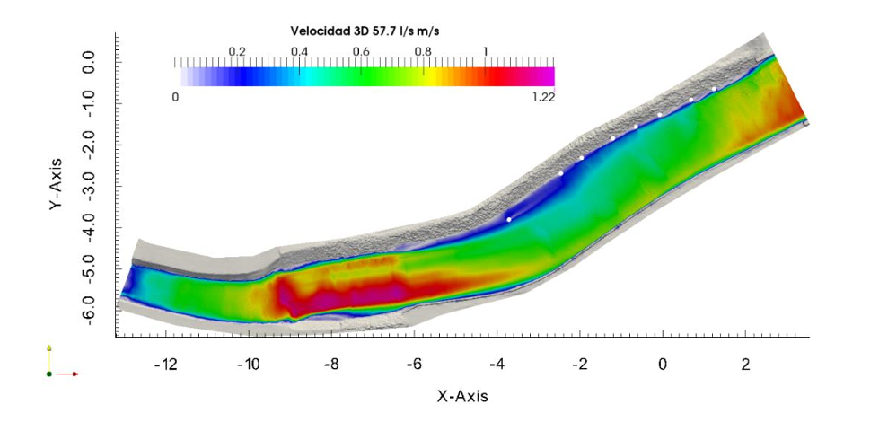
The bachelor thesis titled “Evaluation of a 3D Numerical Model Applied to a Physical Model of the Rímac River” presents a detailed investigation into the simulation of complex riverine flow conditions, specifically focusing on the hydraulic behaviour around grade control structures (known as traviesas) within a curved river reach. The research combines experimental measurements obtained from a physical model constructed at the National Hydraulic Laboratory of UNI, with a three-dimensional numerical model developed using the TELEMAC-MASCARET system.
The primary objective was to evaluate whether a 3D numerical model can accurately replicate observed flow behaviour and erosion patterns downstream of the grade control structures. The numerical model was calibrated using velocity and depth data obtained through ADV (Acoustic Doppler Velocimetry) measurements. The erosion depths estimated with the Bormann and Julien (1991) equation were compared to those measured in the physical model, revealing that the empirical predictions required a correction factor to match observations—suggesting the presence of highly three-dimensional flow structures influenced by channel curvature. Through numerical simulation, it was found that the complex flow field generated multiple localized vortices rather than a single large vortex downstream of the structures. The model calibration and validation were carried out for two flow rates (57.7 and 75 l/s), and the numerical results were compared with those from the physical model. The roughness coefficients, turbulence modelling, and boundary conditions were carefully tuned to achieve realistic flow simulations.
This study demonstrates the feasibility and value of coupling physical and numerical modelling for the analysis of local erosion phenomena in rivers, contributing to better design and risk assessment of hydraulic structures. The outcomes highlight the importance of high-resolution 3D modelling in capturing the asymmetric and turbulent nature of flow in engineered river sections.
Project 2
Two-Dimensional Fluvial Morphodynamic Modeling of Sedimentation and Vertical Erosion Processes at Shallow Sections in the Lower Huallaga River
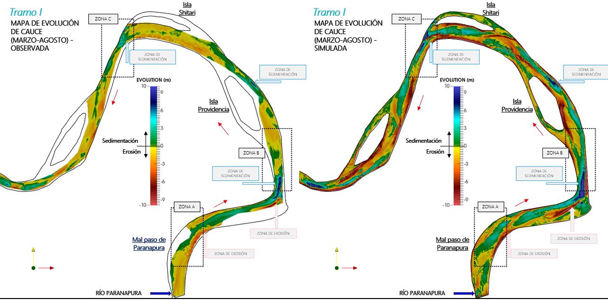
The master’s thesis titled “Two-Dimensional Fluvial Morphodynamic Modeling of Sedimentation and Vertical Erosion Processes at Shallow Sections in the Lower Huallaga River” presents a comprehensive study aimed at understanding the morphodynamic behaviour of sedimentation-prone areas—referred to as “malos pasos”—which impede navigation in the lower section of the Huallaga River in the Peruvian Amazon.
This research employs two-dimensional numerical modelling using the TELEMAC-SISYPHE module to simulate the sediment transport and vertical bed evolution in seven critical shallow zones distributed across three river stretches. The methodology includes (1) the physical and hydrosedimentological characterization of the river stretches, (2) the comparison of bathymetric data from high-flow (March 2018) and low-flow (August 2018) seasons to identify erosion and deposition patterns, and (3) the construction, calibration, and validation of the morphodynamic model.
The analysis revealed that erosion is more pronounced in sectors with resistant tertiary sedimentary rock outcrops, while sedimentation tends to occur near tributary inflows and in low-curvature areas between meander bends. The models were calibrated based on observed bathymetric changes, with simulation accuracy assessed using statistical indicators such as the Nash–Sutcliffe efficiency and correlation coefficients (R ranging from 0.64 to 0.86). The temporal evolution analysis showed the development of large bedforms during peak discharge months (March to June), which diminish in size during the dry season (July to September). Additionally, the study observed shifts in the river’s thalweg that correspond to the emergence of new navigable channels, particularly evident in the “Progreso” shallow zone, where a transformation in the cross-sectional geometry of the riverbed was documented. This work highlights the applicability of 2D morphodynamic modeling for analyzing and forecasting fluvial processes in low-gradient, sediment-laden tropical rivers. The findings provide critical insights for planning river navigation improvements and sediment management strategies in the Amazon basin.
Project 3
Assessing Sea Level Rise Impact on Estuarine Morphodynamics
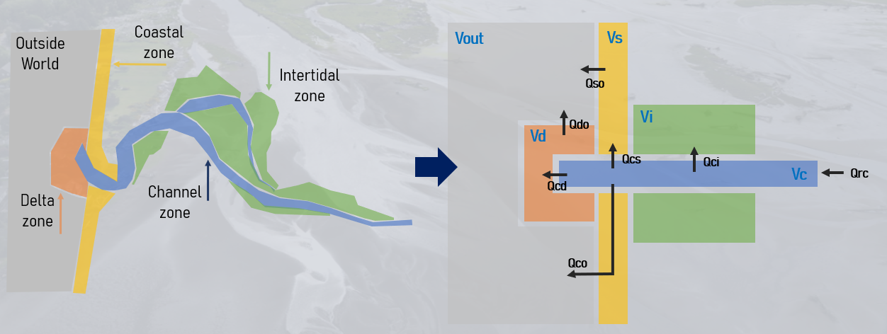
This project explored how estuarine systems respond to sea level rise and variations in sediment supply, using a simplified morphodynamic model known as morQuest. Estuaries are dynamic environments where freshwater and tidal processes interact, and they are increasingly threatened by climate-induced sea level rise. The research focused on estuaries along the U.S. West Coast, including Alsea Bay, Nehalem River, and Coquille River, which are known for their ecological importance and vulnerability to habitat loss.
The project applied a three-phase methodology: (1) sensitivity analysis to identify key model parameters driving estuarine change, (2) model calibration using historical data on intertidal area, river discharge, tidal range, and shoreline slope, and (3) 100-year projections to anticipate long-term morphodynamic evolution under rising sea levels. Using global datasets, satellite imagery, and sea level projections from NASA and the IPCC, the model simulated how estuarine intertidal zones may drown, expand, or shift depending on sediment dynamics. The outcomes offer insights for climate adaptation planning, supporting decisions on coastal habitat conservation and risk mitigation. The project also contributed to the development of a Python version of the morQuest model, enhancing accessibility for future environmental assessments.
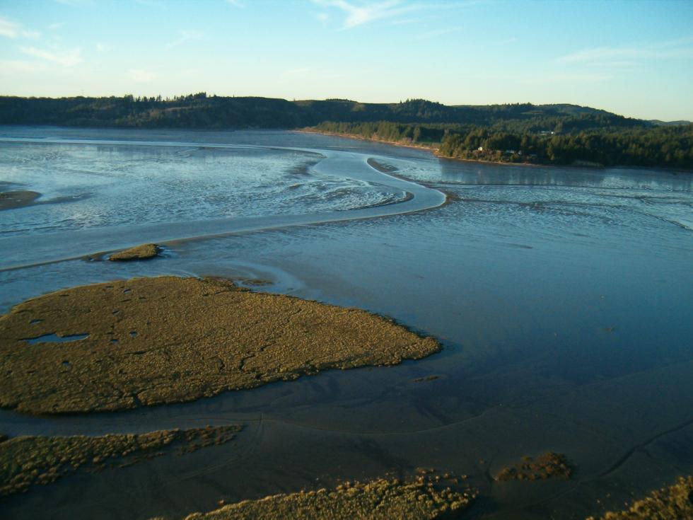
Alsea Estuary Photo Credit: Doug Cottam, ODFW
Project 4
Scientific Description of the Academic Project – Camargue
The project “Go with the Flow – Development of a Long-Term Coastal Management Strategy for the Camargue Region” addresses the urgent challenges posed by climate change to the Mediterranean coastline of southern France, particularly in the Camargue delta. The study integrates environmental, hydrodynamic, and socio-economic analyses to propose adaptive coastal management strategies under projected sea-level rise and increased storm frequency scenarios.
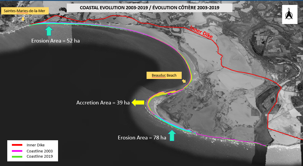
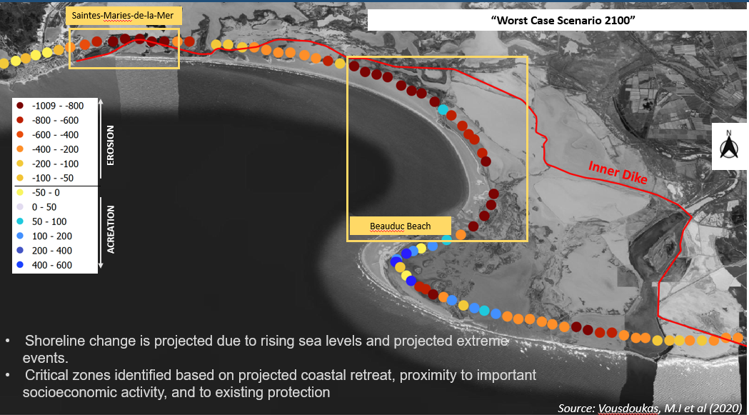
The research evaluates historical shoreline evolution (2003–2019), identifying areas of significant erosion and accretion, and model’s future coastline shifts under a worst-case 2100 scenario. Critical zones such as Saintes-Maries-de-la-Mer are analysed in detail for vulnerability to dike breaching and inundation, projecting permanent and temporary flooding across more than 720 km² of low-lying land. Geotechnical assessments, including sediment diameter and dike structure inspection, provide input for failure modelling under extreme storm conditions. The ecological implications are assessed based on habitat losses for indicator species (e.g., European eel, pink flamingo, pond turtle) and land use change in flood-prone areas. A multicriteria analysis is used to evaluate five integrated management measures—wetland restoration, dike reinforcement, dune restoration, beach nourishment, and dike rehabilitation—based on their performance across environmental, economic, and disaster resilience criteria.
The project concludes that a combination of nature-based and engineered solutions offers the most effective path for preserving the ecological and socioeconomic integrity of the Camargue. It underscores that passive approaches are untenable given the projected impacts, reinforcing the need for proactive, adaptive strategies.
General Projects
River Defenses of the Tumbes River – Package 2 (Peru)
A national-scale flood protection project aimed at mitigating river overflow and debris flow hazards in the Tumbes River Basin—an area frequently affected by El Niño events and extreme rainfall. The intervention involved hydrodynamic modelling (HecRas software) and the design of levees, floodwalls, and channel improvements over a 40 km stretch to protect urban and agricultural zones.
Flood Control Plan for the Rímac River Basin (Peru)
A comprehensive plan to manage floods and mass movements in one of Lima’s most critical watersheds. The study supported disaster risk reduction efforts in the capital region by identifying vulnerable zones, simulating flood scenarios (Iber/FLO2D software), and proposing multi-purpose control structures.
Hydrodynamic Impact Analysis – Amazonian Riverbanks (HIDROVÍAS Project, Peru)
An environmental and engineering assessment along the Marañón, Huallaga, Ucayali, and Amazon rivers to evaluate the impacts of sediment deposits and propose navigational improvements (OpenTelemac software). This was part of Peru’s Hidrovías initiative to ensure year-round river transport while protecting ecosystems and communities.
Pre-investment Study – Flood Protection in Cerro Centinela (Peru)
A feasibility analysis for creating flood mitigation infrastructure to divert flash floods from the San Carlos stream in Trujillo (FLO2D software). The study aimed to protect downstream urban areas through channelling, storage, and controlled discharge to the sea.
La Esperanza Tailings Dam Break Simulation (Peru)
A numerical modelling study assessing the downstream impacts of a hypothetical tailings dam breach. The simulation helped define emergency response zones and informed regulatory compliance for dam safety in mining operations.
Sediment Mitigation Study – Crisnejas River at Potrero Hydropower Plant (Peru)
Evaluated sediment dynamics affecting turbine efficiency and operational safety at the Potrero hydropower facility (Iber and Telemac software). Recommendations included sediment bypass and improved settling basin design to optimize plant performance.